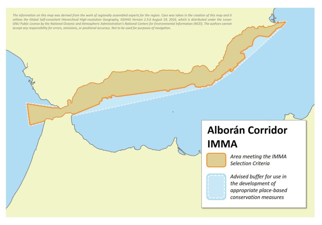
Size in Square Kilometres
20,217
Qualifying Species and Criteria
Sperm whale – Physeter macrocephalus
Criterion A; C (3)
Fin whale – Balaenoptera physalus
Criterion A; C (3)
Criterion D (2) – Marine Mammal Diversity
Other Marine Mammal Species Documented
Delphinus delphis, Globicephala melas, Orcinus orca, Stenella coeruleoalba, Tursiops truncatus
Summary
This area represents a migratory corridor for Vulnerable fin whales (Balaenoptera physalus) in the northern Alborán Sea and Strait of Gibraltar. Fin whales migrating from the inner Mediterranean Sea towards the Atlantic Ocean and vice versa use this corridor bidirectionally, as shown by regular sightings and satellite tagging. This area also encompasses a large portion of the migration routes used by the Endangered Mediterranean subpopulation of sperm whales (Physeter macrocephalus) between the Western Mediterranean and their Ligurian Sea feeding grounds.
Description of Qualifying Criteria
Criterion A – Species or Population Vulnerability
The fin whale (Balaenoptera physalus) Mediterranean subpopulation is listed as Vulnerable in the IUCN Red List of Threatened Species. After several decades of research, it is still unclear which subpopulation or which portion of the subpopulations inhabiting the Mediterranean Sea might use this migration corridor on their way from/to the Atlantic Ocean. However, a large portion of migrating fin whales use the Alborán Corridor regularly.
The sperm whale (Physeter macrocephalus) Mediterranean subpopulation is listed as Endangered in the IUCN Red List of Threatened Species. This area encompasses a large portion of the migration routes used by sperm whales between the Strait of Gibraltar and Ligurian Sea feeding grounds.
Criterion B – Distribution and Abundance
Sub-criterion B1 – Small and Resident Populations
Sub-criterion B2 – Aggregations
Criterion C: Key Life Cycle Activities
Sub-criterion C1 – Reproductive Areas
Sub-criterion C2: Feeding Areas
Sub-criterion C3: Migration Routes
C3a – Whale Seasonal Migratory Route
C3b – Migration / Movement Area
Fin whales use this area as a bi-directional migration corridor, in summer mainly swimming South-west and in winter mainly North-east. This was shown by long-term recorded observations in the Alborán Sea and the Strait of Gibraltar as well as satellite tagging. Five individuals were tagged in summer and winter in the Strait of Gibraltar with Spot5 satellite tags. The three tagged animals have been observed to have passed through the Alborán Corridor.
This area encompasses a large portion of the migration routes used by Mediterranean sperm whales between the Strait of Gibraltar and Ligurian Sea feeding grounds, as can be seen on Figure 2 and by satellite tracking of 2 individuals from the Strait of Gibraltar to the NW Mediterranean Sea.
Criterion D – Special Attributes
Sub-criterion D1 – Distinctiveness
Sub-criterion D2 – Diversity
Supporting Information
Bentaleb, C., Martin, M., Vrac, M., et al. 2011. Foraging ecology of Mediterranean fin whales in a changing environment elucidated by satellite tracking and baleen plate stable isotopes. MEPS: 438:285-302.
de Stephanis, R. et al. 2008.Summer spatial distribution of cetaceans in the Strait of Gibraltar in relation to the oceanographic context. Marine Ecology Progress Series,353, 275-288.
de Stephanis, R., et al. 2012. Critical Habitat for Sperm Whales in The South-West Mediterranean Sea. 26th Ann. Meeting European Cetacean Society, Galway, Ireland, 26-28 March 2012.
Gauffier, P. et al. 2012. Winter presence of large cetaceans in the Strait of Gibraltar. 26th Ann. Meeting European Cetacean Society, Galway, Ireland, 26-28 March 2012.
Gauffier, P. et al. 2009. An update on fin whales (Balaenoptera physalus) migration through intense maritime traffic in the Strait of Gibraltar. International Whaling Commission document SC/61/BC6, Madeira, Portugal. 4 pp. Available at http://iwcoffice.org/.
Notarbartolo di Sciara, et al. 2016. Fin Whales, Balaenoptera physalus: At Home in a Changing Mediterranean Sea? Advances in Marine Biology, 75: 75-101.
Downloads
Download the full account of the Alborán Corridor using the Brochure button below:
To make a request to download the GIS Layer (shapefile and/or geojson) for the Alborán Corridor please complete the following Contact Form:


