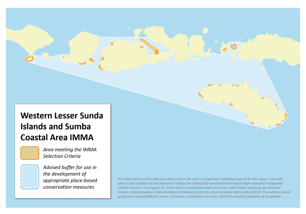
Western Lesser Sunda Islands and Sumba Coastal Area IMMA
Size in Square Kilometres
759 km2
Qualifying Species and Criteria
Dugong – Dugong dugon
Criterion A; B (1); C (2)
Marine Mammal Diversity
Stenella longirostris, Stenella attenuata
Download fact sheet
Summary
The Lesser Sunda Coastal Area (LSCA) comprises a non-contiguous area of water and small islands from Bali to the Wetar Islands. It contains the four provincial administrative areas of Bali, West Nusa Tenggara (WNT), East Nusa Tenggara (ENT) and Maluku. The Western Lesser Sunda Islands and Sumba coastal area IMMA consists of coastal areas of the Bali Islands, Lombok Islands, Sumbawa Islands, the western part of Flores, and Sumba Island. This IMMA has numerous seagrass meadows and a large number of sightings of dugong. Sighting information from a participatory mapping process (which gathered information from more than 1500 respondents), the coastal community’s local knowledge, a ground-truthing survey and direct sightings, have confirmed that dugongs are found at 41 locations within the area. Sightings are mostly of single individuals, and three individuals sighted in Komodo National Park. The species is increasingly vulnerable due to habitat loss and habitat overlap with human activities such as seaweed farming.
Description of Qualifying Criteria
Criterion A – Species or Population Vulnerability
Dugong dugon (Muller, 1776) has been assessed as a Vulnerable species on the IUCN Red List since 1982. The data on dugongs in Indonesia or even in Lesser Sunda remains limited. It is estimated that there are around 1,000 individuals in Indonesia (Marsh et. al. 2002). Therefore, the Indonesian government declared the dugong as a fully protected species along with all other marine mammals (Government Regulation – No. 7. 1999). The species is becoming increasingly vulnerable due to habitat lost and overlap with human activities such as none eco-friendly seaweed farming activities.
Criterion B: Distribution and Abundance
Sub-criterion B1: Small and Resident Populations
According to sightings information from a participatory citizen mapping process, that gathered information from more than 1500 fishers and coastal community’s local knowledge, as well as ground-truthing surveys and direct sightings, dugongs have been recorded in at least 41 locations within the area. Most were single individuals, and 3 individuals sighted in Komodo National Park (Mustika, 2005; Merryanto et al. 2017; unpublished data from The Nature Conservancy, unpublished data from Misool Foundation). Individual dugongs have been sighted by surfers at Uluwatu and Padang beaches on the southwest extremity of the South Bali Peninsula (Marsh, 2002).
Criterion C: Key Life Cycle Activities
Sub-criterion C2: Feeding Areas
In the Lesser Sunda Coastal Area dugongs are recorded close to seagrass areas (Merryanto et al. 2017), in particular around beds of Halophila ovalis, Halodule uninervis, Enhalus acoroides, Thalassia hemprichii, Cymodocea rotundata, Cymodocea serrulata, and Syringodium isoetifolium.
Supporting Information
Juraij, S.D., Tania, C., Wijanarko, T., Khaifin, Santiadji, V. and Hadinata, S.Y. 2016. Survey dugong habitat (Survey of dugong and seagrass habitat). Technical report. WWF-Indonesia.
Juraij, S.D. and Munandar, E. 2017. Survey bioekologi dan tingkah laku dugong di Kelurahan Kabola perairan SAP Selat Pantar dan Laut Sekitarnya Kabupaten Alor, Nusa Tenggara Timur (Bioecology and behaviour survey of dugong in Kabola village waters of Pantar Strait and surrounding waters Nature Marine Sanctuary, Alor District, East Nusa Tenggara). Technical report. WWF-Indonesia.
Kahn, B. 2003. Solor-Alor Visual and Acoustic Cetacean Surveys. Interim Report April – May 2003 Survey Period. The Nature Conservancy and APEX Environmental Cetacean Survey.
Khan, B. and Fajariyanto. Y. 2014. Rapid Ecological Assessment (REA) for Cetaceans in the Savu Sea Marine National Park. The Nature Conservancy – Indonesia Coasts and Oceans Program. 45 pp.
Marsh, H., Penrose, H., Eros, C. and Hugues, J. 2002. Dugong status report and action plan for countries and territories. UNEP. Early warning and assessment report series. 162 pp.
Mustika, P.L.K. 2005. Linking the two seas: Lessons learned from Savu Sea (Indonesia) for marine mammal conservation in Timor Sea. Contribution to Pacem in Maribus XXXI Conference 31 October – 3 November 2005.
Mustika, P.L.K. 2006. Marine mammals in the Savu Sea (Indonesia): Indigenous knowledge, threat analysis, and management options. For the degree of Master of Science. James Cook University.
Putra, M.I.H., Topan E. and Lewis, T. 2017. Marine Megafauna in Solor Waters, East Flores – East Nusa Tenggara, Indonesia 2016 – 2017. Misool Foundation, Savu Sea Program, Indonesia. 61 pp.
Spalding, M.D., Fox, H.E., Allen, G.R., Davidson, N., Ferdaña, Z.A., Finlayson, M, Halpern, B.S., Jorge, M.A., Lombana, A., Lourie, S.A., Martin, K.D., McManus, E., Molnar, J., Recchia, C.A. and Robertson, J. 2007. Marine Ecoregions of the World: a bioregionalization of coast and shelf areas. BioScience 57: 573-583.
Welly, M., Lazuardi, M.E., Sanjaya, W., Prasetya, D. and Hendrawan, G. 2016. Kondisi biofisik dan social ekonomi Pesisir Bali-2015. Denpasar: Pemerintah Provinsi Bali dan The Nature Conservancy.
Wen, W., Hutasoit, P., Tomasouw, J., Wibowo, J.T., Jompa, J. and Wijonarno, A. 2015. Kajian biofisik pembentukan jejaring Kawasan Konservasi Perairan di wilayah Bentang luat Sunda Kecil. Kemeterian Kelautan dan Perikanan. Supported by: WWF-Indonesia & Nusa Dua Reef Foundation.
Merryanto, Y., Rusydi, Sri, N., Vimeris, M. T. and Fajariyanto, Y. 2017. Pemetaan Partisipatif di Ekoregion Sunda Kecil (Participatory mapping of Lesser Sunda Ecoregion). The Nature Conservancy – Indonesia Coasts and Ocean Program. 140 hal.


