Size in Square Kilometres
2467
Qualifying Species and Criteria
Dugong – Dugong dugon
Criterion A; C (1, 2)
Criterion D (2) – Marine Mammal Diversity
Other Marine Mammal Species Documented
Summary
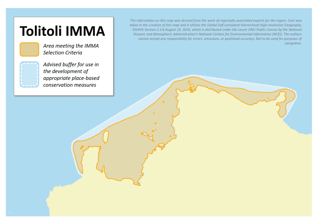
Tolitoli is located in Central Sulawesi, Indonesia. It is recognised as one of the most important habitats for dugong (Dugong dugon), a species listed as vulnerable on the Red List. The boundary selection of the Tolitoli IMMA is based on the core area of inshore dugong sightings obtained during aerial, boat and feeding trail surveys in 2016 and community information collected before and during the survey. Satellite-based data mapping in 2010 confirmed the presence of numerous seagrass meadows in the area. The outer boundary of the IMMA aligns with the Convention on Biological Diversity Ecological or Biological Significant Area (EBSA) region that encompasses the entire the Tolitoli area considering the full possible range of dugong.
Description of Qualifying Criteria
Criterion A – Species or Population Vulnerability
The dugong (Dugong dugon) is threatened species, currently listed as a ‘Vulnerable (A2bcd+4bcd)’ species based on the IUCN Red List (Marsh and Sobtzick, 2015). Data on the dugong population size in Tolitoli and in wider Indonesia remains limited. Marsh et al. (2002) cited around 1,000 individuals in Indonesia. All marine mammals, including dugongs, are fully protected by the Indonesian government (Government of The Republic of Indonesia, 1999). Because of the dugong’s relatively slow life history, population recovery after a perturbation will be slow.
Criterion B – Distribution and Abundance
Sub-criterion B1 – Small and Resident Populations
Sub-criterion B2 – Aggregations
Criterion C: Key Life Cycle Activities
Sub-criterion C1 – Reproductive Areas
Scientific surveys and community sightings report that dugongs use the Tolitoli area for both feeding and reproduction. The domestication of two dugongs for nine years in Santigi village, Tolitoli (Herandarudewi et al. 2016), commenced when the locals started caring for dugong calves found in the area, demonstrating that the area may be crucial for the nursing of the wider population.
Sub-criterion C2: Feeding Areas
Dugongs have been observed foraging on seagrass beds in Jelaje village, Tolitoli. Serpentine dugong feeding trails have also been recorded in this area, indicating that dugongs forage upon these seagrass beds (Herandarudewi et al. 2016) leaving a distinctive track. The location in which feeding trails were found close to the areas where dugongs were most frequently recorded (Herandarudewi et al. 2016). Halodule uninervis, Cymodocea serrulata, Halophila ovalis and Thalassia hemprichii were the most abundant seagrasses in the vicinity of the feeding trails. The number of feeding trails in the seagrass meadows close to Jelaje Village indicate that this location is dugong foraging habitat.
Sub-criterion C3: Migration Routes
C3a – Whale Seasonal Migratory Route
C3b – Migration / Movement Area
Criterion D – Special Attributes
Sub-criterion D1 – Distinctiveness
Sub-criterion D2 – Diversity
Supporting Information
Government of The Republic of Indonesia. 1999. Peraturan Pemerintah No. 7 Tahun 1999 tentang Pengawetan Jenis Tumbuhan dan Satwa (Government Regulation No. 7/1999 on Preserving Flora and Fauna Species). [Online]. Available at: http://ksdae.menlhk.go.id/assets/uploads/Lampiran-PP-Nomor-7-Tahun-1999.pdf
Herandarudewi, S.M.C., Juraij, Munandar, E., Riswanto, Arifin, A., Anggraeni, F., Suhardi, Suprapti, D., Endano, Y., and Hadinata, S.Y. 2016. Laporan Sementara Survey Lapangan Habitat Dugong dan Lamun di Tolitoli 19-26 September 2016 (Report on Preliminary Field Survey on Dugong and Seagrass Habitat in Tolitoli, 19-26 September 2016). Bali-Indonesia. 66 pp. Dugong and Seagrass Conservation Projects (DSCP) Indonesia.
Marsh, H., and S. Sobtzick. 2015. Dugong dugon. The IUCN Red List of Threatened Species 2015: e.T6909A43792211. [Online]. Available at: http://dx.doi.org/10.2305/IUCN.UK.2015-4.RLTS.T6909A43792211.en.
Marsh, H., Penrose, H., Eros, C. and Hugues, J. 2002. Dugong status report and action plan for countries and territories. Cambridge, United Kingdom: UNEP. Early warning and assessment report series. 162 pp. [Online]. Available at: http://wedocs.unep.org/handle/20.500.11822/8170
Supriyadi, H.I. 2010. Pemetaan padang lamun di perairan Teluk Tolitoli dan Pulau Sekitarnya, Sulawesi Barat (Mapping of Seagrass Beds in Tolitoli Bay and Surrounding waters, Sulawesi Barat). Oseanologi dan Limnologi di Indonesia, 36(2): 147-164.
Downloads
Download the full account of the Tolitoli IMMA using the Brochure button below:
To make a request to download the GIS Layer (geopackage and/or geojson) for the Tolitoli IMMA please complete the following Contact Form: