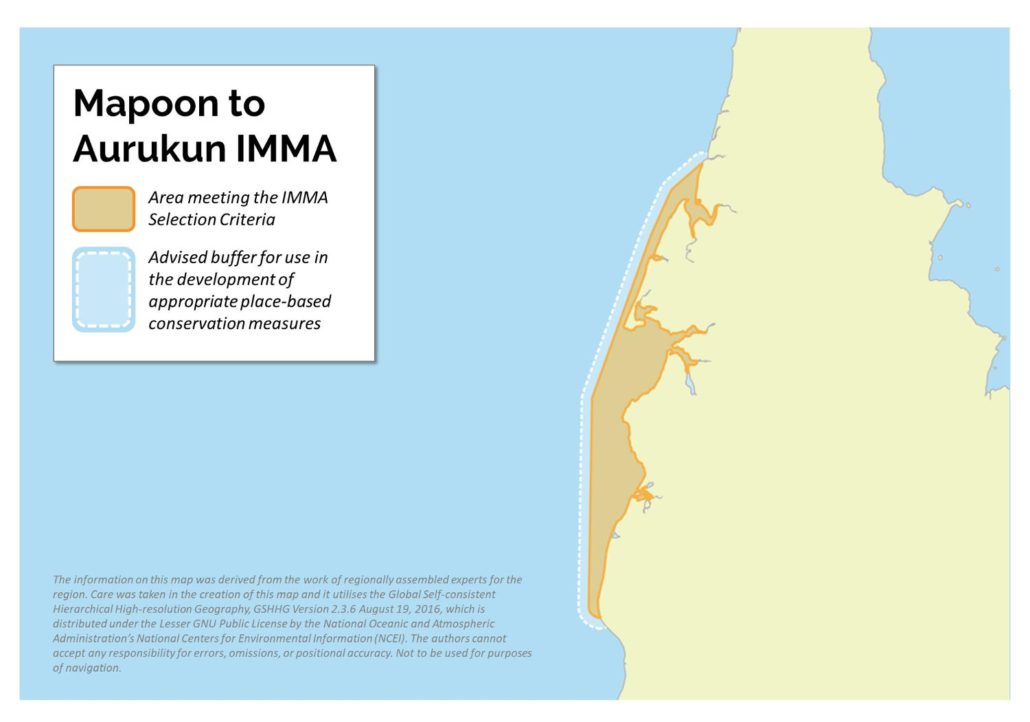
Mapoon to Aurukun IMMA
Size in Square Kilometres
3,905 km2
Qualifying Species and Criteria
Australian snubfin dolphin – Orcaella heinsohni
Criterion A; B (1)
Australian humpback dolphin – Sousa sahulensis
Criterion A; B (1)
Marine Mammal Diversity
Tursiops aduncus, Pseudorca crassidens, Orcinus orca, Stenella longirostris
Download fact sheet
Summary
This IMMA is in the far north of the western side of Cape York in Queensland, Australia, from the Aurukun Shire in the south to the Mapoon Shire in the north. It features the two largest coastal embayments along the western Cape York coast, Albatross Bay, near Weipa and Port Musgrave near the town of Mapoon. Large drainage basins that discharge into estuaries supporting productive prey assemblages, seagrass pastures and mangroves. Adjacent offshore reefs provide foraging habitat for dolphins and whales. Australian humpback dolphins, Australian snubfin dolphins and dugongs (Marsh, 2008) are resident in the area, especially in Port Musgrave and Albatross Bay and along the adjacent coastline. The area also includes important populations of other threatened species such as sawfish, crocodiles and the critically endangered speartooth shark, and encompasses foraging and nesting habitat for marine turtles. False killer whales are thought to seasonally migrate through the area (Trevor Long, unpublished observations), and feeding aggregations of Bryde’s whales and spinner dolphins have been reported offshore. Killer whales have also been occasionally reported in the area. A total of 269 marine mammal sightings have been recorded for the area (Queensland Department of Environment and Science, unpublished data).
Coastal dolphins in the area from Weipa to Aurukun were monitored from 2014 to 2018 as part of the approvals and planning for the Rio Tinto Amrun Project, by GHD and Blue Planet Marine. Pilot surveys were also undertaken by the Queensland Department of Environment and Science and the Mapoon Land and Sea Rangers in 2017, covering the area from Pennyfather Creek to the Skardon River. Incidental sightings are regularly recorded by ecotourism operators and during marine turtle nesting monitoring. Dugongs were sighted in the area during an intensive aerial survey in 2007 (Marsh 2008) but the numbers were too small to estimate the population size.
Description of Qualifying Criteria
Criterion A – Species or Population Vulnerability
Threatened species that are resident in this area include substantial populations of Australian humpback dolphins as well as and Australian snubfin dolphins. These dolphin species are listed as Vulnerable on the IUCN Red List, as well Queensland Nature Conservation Act of 1999, and the Australian Nature Conservation Agency (NCA) (Parra et al., 2017a, Parra et al., 2017b).
Criterion B: Distribution and Abundance
Sub-criterion B1: Small and Resident Populations
Unpublished estimates of the population sizes from four years of photographic mark recapture surveys in the area from Weipa to Aurukun suggest a population of 183-230 humpback dolphins from 2014-2018 for an area of ~1,000 km2 (GHD 2015, Blue Planet Marine, unpublished data). Small numbers of Australian snubfin dolphins were also photo identified in 2019 in Blue Planet Marine surveys (Planet Marine, unpublished data). In the area from Pennyfather Creek to the Skardon River, 37 Australian humpback dolphins and 12 Australian snubfin dolphins were photo identified in 189 km of vessel transects over four days (Meager 2018). These survey routes were primarily aimed at determining the overall spatial hotspots for coastal dolphins. A detailed understanding of relative habitat suitability or dolphin density would require a replicated systematic survey and much more survey effort than four days. Even so, the results suggest that the core habitat use areas of both species are likely to be centred around Port Musgrave because both species were only encountered within 16 km of the Port (surveys extended 40 km south and 20 km north of the Port).
Historical records of dolphins in the region are sparse. A group of two snubfin dolphins was recorded in Port Musgrave in aerial surveys undertaken in 1997 (Marsh et al. 2000). In the 1990s, Australian snubfin dolphins were regularly seen near Cullen Point (at the entrance to Port Musgrave) and out to Kerr’s reef (~10 km from the mainland, Trevor Long, pers. comm.), suggesting movements outside of the port area. Australian humpback dolphins are regularly reported along the Flinders and Back Beach during marine turtle nesting surveys undertaken in late winter (Colin Limpus, pers. com.). In addition, 14 Australian snubfin and 11 Australian humpback dolphins were recorded foraging in a 2 km stretch of the lower Wenlock River (up to ~ 5 km upstream) – suggesting that the area could be an important foraging area. This aligns with the high densities of other piscivorous species in the area such as estuarine crocodiles and elasmobranch fishes.
Supporting Information
Blue Planet Marine. 2019. Amrun project 2018 inshore dolphin survey report.
GHD. 2015. Rio Tinto Alcan: south of the Embley Inshore Dolphin Project December 2014 Baseline Survey. http://citeseerx.ist.psu.edu/viewdoc/download?doi=10.1.1.734.3687&rep=rep1&type=pdf
Marsh, H. 2008. Distribution and abundance of dugong in the Gulf of Carpentaria water: a basis for cross jurisdictional conservation planning and management. Australian Centre for Applied Marine Mammal Science Final Report.
Marsh, H., Corkeron, P., Preen, T. and Pantus, F. 2000. Aerial survey of marine wildlife in Gulf of Carpentaria waters adjacent to Queensland. Townsville, Qld.
Meager, J. 2018. Conservation management of dolphins of the Mapoon region: pilot study in 2017. Department of the Environment and Science, Queensland, Brisbane
Parra, G., Cagnazzi, D., Perrin, W. & Braulik, G.T. 2017a. Sousa sahulensis. The IUCN Red List of Threatened Species 2017: e.T82031667A82031671. https://dx.doi.org/10.2305/IUCN.UK.2017-3.RLTS.T82031667A82031671.en.
Parra, G., Cagnazzi, D. & Beasley, I. 2017b. Orcaella heinsohni (errata version published in 2018). The IUCN Red List of Threatened Species 2017: e.T136315A123793740. https://dx.doi.org/10.2305/IUCN.UK.2017-3.RLTS.T136315A50385982.en.


